Sistema de Acesso Remoto a Dados de Sonar Aplicada ao Monitoramento da Ictiofauna no Setor Hidrelétrico
REGISTRO DOI: 10.5281/zenodo.8194563
A. S. Santos1
L. F. Zara2
J. Rocha3
ABSTRACT
This paper presents the activities of gathering requirements, design, proof of concept and development of a solution for remote activation and automation of hydroacoustic equipment (SONAR – Sound, Navigation and Ranging). The motivation was the possibility of creating a technology to minimize environmental impacts on the ichthyofauna in the area of direct influence of Hydroelectric Power Plants (HPP). A prototype was validated at HPP Jirau on the Madeira River, Rondônia. The focus was on using the solution for real-time monitoring of the movement of ichthyofauna at fixed points on the HPP structures. It was possible to monitor in real time the movement of the ichthyofauna in these areas over long periods of time by obtaining information. The commissioning of the prototype required system adaptations and hardware and software improvements. The technology applied to the sonar showed high stability and robustness, being easy to adapt to different applications in different HPP.
Keywords: Hydroelectric power plant, sonar, remote access, ichthyofauna, environmental impacts.
RESUMEN
Este trabajo presenta las actividades de levantamiento de requerimientos, diseño, prueba de concepto y desarrollo de una solución para activación remota y automatización de equipos hidroacústicos (SONAR – Sound, Navigation and Ranging). La motivación fue la posibilidad de crear una tecnología para minimizar los impactos ambientales sobre la ictiofauna en el área de influencia directa de las Usinas Hidroeléctricas (UHE). Un prototipo fue validado en la UHE Jirau en el río Madeira, Rondônia. La atención se centró en utilizar la solución para el seguimiento en tiempo real del movimiento de la ictiofauna en puntos fijos de las estructuras de la HPP. Mediante la obtención de información fue posible monitorear en tiempo real el movimiento de la ictiofauna en estas áreas durante largos períodos de tiempo. La puesta en marcha del prototipo requirió adaptaciones de sistema y mejoras de hardware y software. La tecnología aplicada al sonar mostró alta estabilidad y robustez, siendo fácil de adaptar a diferentes aplicaciones en diferentes UHE.
Palabras clave: Centrales hidroeléctricas, sonar, acceso remoto, ictiofauna, impactos ambientales.
RESUMO
Esse trabalho apresenta as atividades de levantamento de requisitos, projeto, prova de conceito e desenvolvimento de solução de acionamento remoto e automação de equipamentos hidroacústico (SONAR – Sound, Navigation and Ranging). A motivação foi a possibilidade de criar uma tecnologia para minimizar impactos ambientais na ictiofauna na área de influência direta de Usinas Hidrelétricas (UHE). Um protótipo foi validado na UHE Jirau no Rio Madeira, Rondônia. O foco foi a utilização da solução no monitoramento em tempo real da movimentação da ictiofauna em pontos fixos das estruturas da UHE. Foi possível o monitoramento em tempo real da movimentação da ictiofauna dessas áreas durante longos períodos com a obtenção de informações. O comissionamento do protótipo exigiu adaptações no sistema e melhorias de hardware e software. A tecnologia aplicada ao sonar apresentou eleva estabilidade e robustez, sendo de fácil adaptação para diversas aplicações em diferentes UHE.
Palavras-chave: Hidrelétricas, sonar, acesso remoto, ictiofauna, impactos ambientais.
1 INTRODUCTION
Hydroelectric Power Plants (HPP) are complex systems to build and involve electric, civil, energy, and mechanic engineering projects. In this process, several knowledge areas are involved: geotechnology, geology, hydraulics, computing, automation, environmental control, forest control, among others. HPPs are a means of producing electricity using renewable sources with low greenhouse gas emissions (CARRINGTON; STEPHENSON, 2018). This set of factors motivates the growth of installed power capacity due to the country’s economic, social, and energy benefits. For countries such as Brazil, they are a means of energy production that is safer and longer-lasting (MORETTO et al., 2012).
Another critical factor is the energy potential to be exploited. Currently, the estimated Brazilian potential varies from 100,000 to 250,000 MW, and in the current technology state, around 160,000 MW are already in place and working. According to data from the Brazilian Company of Energy Research (Empresa Brasileira de Pesquisa Energética – EPE), in 2019, the hydraulic energy matrix was around 65,7% with 1,254 power plants in operation and presented between 2018 and 2019 an expansion of 2.3%, which corresponds to 397,877 GW produced in 2019. This data points to Brazil’s energy reality and dependence on its river basins, both in growth and territory management (THÉRY; MELLO-THÉRY, 2016).
When following the energy expansion by building new HPPs, one can realize that the Amazon is highlighted as the new frontier of hydroelectric resources for Brazil. The Amazonas River Basin holds 42.2% of the entire Brazilian hydroelectric potential (DE ENERGIA ELÉTRICA, 2016), and from the five largest HPPs in Brazil, four are in the Amazon Region. Furthermore, there is extensive planning for the construction and expansion of enterprises and the development of several HPPs in the area.
Consequently, it is necessary to monitor the ichthyofauna present in the aquatic ecosystems in the direct and indirect influence areas of the HPPs, to minimize the environmental impacts in these areas (WINEMILLER et al., 2016). The use of technology and hydro-acoustic systems such as the SONAR (Sound, Navigation, and Ranging) have made it possible to map large areas relatively quickly. At the same time, it obtains georeferenced coordinates of the images and data collected (WESTPHAL et al., 2016). It is also possible to carry out more detailed and precise studies and research.
The use of sonars for location, verification of abundance, and behavioral analysis of ichthyofauna began in 1929 (SIMMONDS; MACLENNAN, 2008), and the main advantages of this methodology are: the ichthyofauna is not hurt, nor does it suffer interference when sampled; the possibility of sampling larger areas relatively quickly; high resolution and reliability spatial/temporal data are acquired at the time of sampling (PRADO, 2012). Equipment-generated sound waves are propagated throughout the body of water until they reach the target and return, via echo, to the emitting system.
Considering the premises for the sustainable development of the hydroelectrical sector, it is of paramount importance to have technologies of remote access to hydro-acoustic systems dedicated to the ichthyofauna monitoring using low-cost hardware (ANDRADE; SOMA; EIKI, 2016) with the development of free, open-source software (BUSCOMBE, 2017). This paper presents the activities of requirement gathering, design, proof of concept, and development of a solution for remote activation and automation of hydro-acoustic equipment.
2 MATERIALS AND METHODS
For the development of this work, the focus was an experimental model. The study considered the previous knowledge of needs and difficulties faced when operating in real-time and when acquiring information of the ichthyofauna movement during more extended periods of usage of hydro-acoustic systems in direct and indirect influence areas HPPs. We interviewed company technicians, researchers, and professionals that work daily at an HPP. The foundation of these needs came from the account of these professionals when collecting sonar data dedicated to ichthyofauna movement monitoring. After defining this need, the development of hardware and software happened as follows: Study of the practices of data acquisition from sonars; Gathering of requirements – activities; Technology analysis; Hardware design and build; Software development; Prototype validation; Integration study with ichthyofauna recognition technologies.
2.1. Study area
The commissioning of the system was developed at the buildings of the HPP Jirau (Image 1), contemplating the powerhouse (L1/P1), the spillway (C/P2), and the system for driftwood retention (L2/P3). HPP Jirau was built on the Madeira River, in the state of Rondônia, 120 km away from Porto Velho, and has a reservoir with an area of 361.6 km2 at its peak volume.
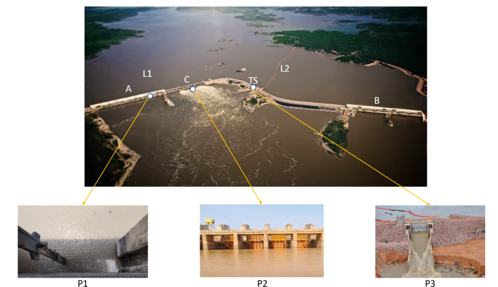
Image 1. Distribution of the buildings at HPP Jirau. A) Powerhouse 1 (GU01 to GU28); B) Powerhouse 2 (GU29 to GU50); C) Spillway (V01 to V18); L1) Log Boom system/right margin; L2) Log Boom system/left margin; TS) System for unloading/transposition of driftwood.
Source: Author (2022)
The energy generation capacity is 3,750 MW, with an assurance of 2,184 MW of continuous capacity. In an area with a humid tropical climate, the annual precipitation is around 1,900 to 2,200 mm. The annual streamflow of this large river is around 18,500 m3s-1 and reaches 45,000 m3s-1 in the flooding period. The power plant has 50 bulb-type turbines (Generating Units – GU) and was first put in operation in December 2016. It has an installed capacity of 3,750 MW, and its reservoir inundated an area of 108 km2.
2.2 Equipment
The requirements gathered set the groundwork for the proposal that devised the prototype. Initially, the project wanted to supply only the remote activation of the sonar equipment from great distances. The processing central considered was RaspberryPi – a minicomputer explicitly made for automation and, due to the high processing power, new sensors were added to the project. It was possible to add temperature and humidity information, monitor the battery’s voltage, and add a solar panel to provide for the energy autonomy of the base. The captured data were much abundant. With that, the remote activation platform was defined, and we created a diagram (Image 2) with the system’s main components.
On top of the software developed for controlling the Prototype of Remote Access to Sonar Data (PADS), we developed a web interface and code for the module control. The access is done through any web browser through a link. Web services were implemented with safety and ruggedness in case of failures using free, open-source technologies. The concept of Application Programming Interface (API) was present throughout the development, and a set of services was created: setSonar, getSonarStatus, getTemperaturaInterna, getTemperaturaExterna, getUmidadeExterna, setMicroSd, getMicroSD, clearMicroSD, getDadoBase, setActivateTime, and setSleep.
The technologies used in developing the control software of the PADS, both interface and services, were basically: HTML5, Javascript, Bootstrap, and Jquery for the front-end; and Python, Flask, python package AM2320, and python package DS18B20 for the back end. Besides, we used Garmin technologies such as the app ActiveCaptain and TeamViewer, which allowed for access to the device when combined.
Based on the diagram, two equipment versions were developed. The first unit for concept testing is a proof-of-concept (POC) of the idea. Afterward, the 1.0 version of the PADS was conceived. This 1.0 model followed the same construction standards as its concept counterpart. Every component from the POC was reused, except for the base and the plastic organizer. In addition, we added some ruggedness to the assembly since the concept version did not consider the actual operating conditions in the study area. The PADS was designed to withstand more demanding field conditions, starting with the assembly structure: a larger box with a metal base, two batteries for operation, two solar panels for charging, one Virtual Private Network (VPN) technology to maintain a safe and robust peer-to-peer communication (we used the Hamachi VPN, very popular among computer gamers) and a new web interface for activation and sensor reading.
In this system, we used the GARMIN GPSMAP 8612xsv system, with two slots for 32GB microSD memory card (the maximum supported), with connections to 12-PIN XDCR, 8-PIN XDCR, and LVS XDCR (LiveScope) transducers and maximum operating power of 72 Watts at 12 Volts. We decided on the GT40-TM transducer that operates in the 77/220 kHz frequencies at 500 Watts in the DownVü/SideVü visualizations and CHIRP at 455/880 kHz frequencies at 500 Watts.
Image 2. Schematic of the remote activation platform. (A – Charging control module (30A 12v 24v Pwm); B – Solar panel (Sinosola 60W); C – SONAR Display (GPSMAP 8612xsv by Garmin); D. – Sealed 12v/7a battery (any brand); E. – Antenna module for GPS USB (Timezero Maxsea); F- Internal temperature and humidity sensor (code AM2320); G
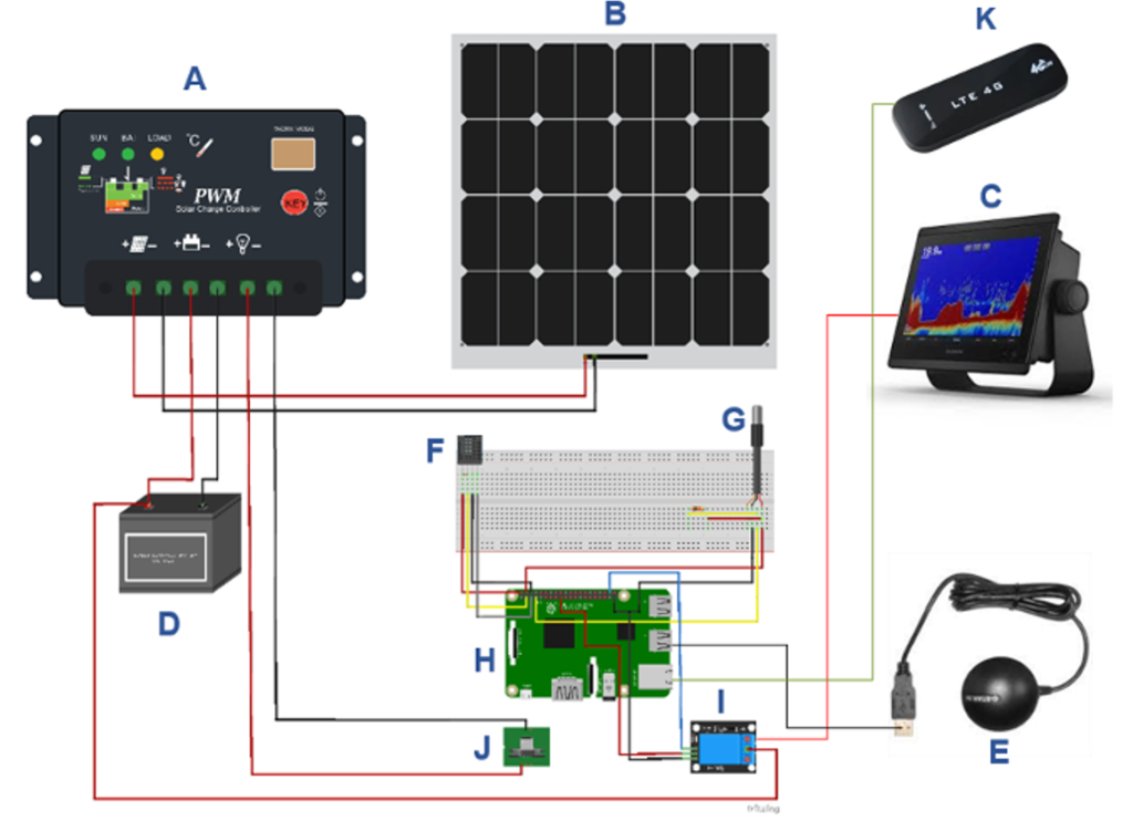
External waterproof temperature sensor (code DS18B20); H – Central processing module – RaspberryPie 3B; I – Activation relay; J – Main power connector); K – 4G module to access the 4G network (QR91F 4gwifi100M +).
Source: Author (2022)
2.3 System commissioning / Field activity
At the powerhouse of the HPP Jirau, the PADS was used to follow ichthyofauna movement in the suction tube in real-time during the planned shutdown. First, in the front panel of the fixed roller gate, we fixed the transducers around 14 meters above the gate’s base (Image 3), where it was possible to obtain a central field of view of the suction tube after the closure of this section. Then, the transducers were connected via cable to the PADS on the higher slab of the powerhouse, and the system operated remotely during the operational maneuver MO-COPE-US-67-SH-UG-00002 (Silva et al., 2021).
The commissioning of the PADS downstream from the HPP’s spillway used a system for transducer fixation in the center of the well allowing for a temporal evaluation of the ichthyofauna movement (Image 4). The transducers were connected via cable to the PADS on the higher slab downstream spillway, and the system was remotely operated for 8 hours.
The PADS was fixated on the structure of the driftwood retention system (Log Boom) and connected via cable to a hydro-acoustic multi-frequency transducer, being remotely operated for 8 hours. The fixation point of the PADS was around 1.0 km upstream from the HPP Jirau (Image 5).
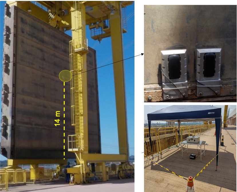
Image 3 – Hydro-acoustic transducers set on the face of the fixed roller gate of the HPP Jirau, connected to the PADS. (9°16’06.7″S 64°38’41.9″W).
Source: Adapted from Silva Et. Al., 2021.
During the commissions, we evaluated the battery’s autonomy and charging, the mobile 3G/4G networks performance and reach at the whereabouts of HPP Jirau, the SONAR’s remote operation during the recordings, the equipment’s internal and external operating temperatures, and the ruggedness during transport, that is, the settling of the internal components, and possible damages during the transport of the PADS.
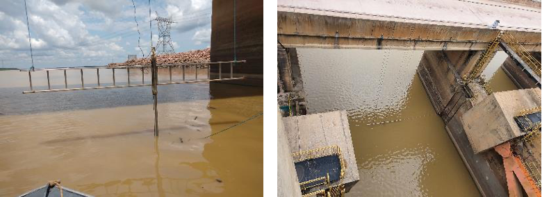
Image 4 – Hydro-acoustic system positioned on the axis transverse to the downstream well of the HPP Jirau’s spillway (9°15’55.8″S 64°38’57.9″W).
Source: Author (2021)

Image 5 – PADS set up on the driftwood retention system (Log Boom) of HPP Jirau (9°15’55.8″S 64°38’57.9″W).
Source: Author (2021)
3 RESULTS AND DISCUSSION
3.1. Equipment assembly
After the development stage, we manufactured the Prototype of Remote Access to Sonar Data (PADS) according to the description in Image 6. We proposed a piece of equipment that used hardware and software to operate and access a SONAR remotely to provide data from long distances. The system aims to speed up SONAR image analysis to minimize environmental impacts to the ichthyofauna close to HPP Jirau.
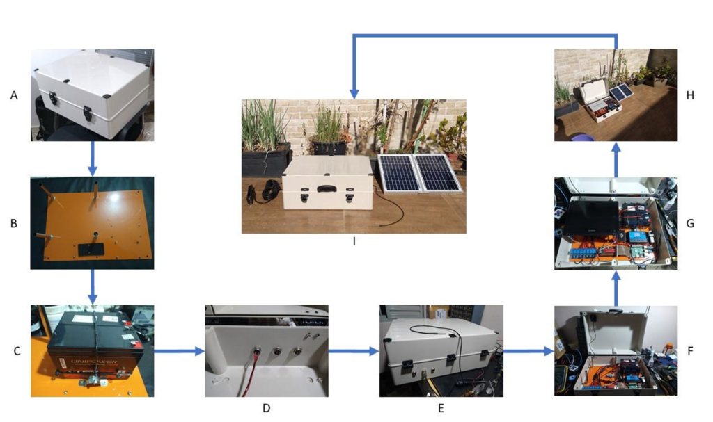
Image 6. PADS assembly sequence: A) Case in PVC (500mm x 380mm x 200mm) with lock and hinge (installation of a handle to become a suitcase); B) Drilling of the plate for module fixation; C) Fastening of the set of batteries; D) Drilling, connector installation and cable connection; E) Setup of the external cables – solar panels, external temperature sensor and external power supply; F) Fastening of the modules and passing cables and connections; G) Finishing touches on the setup of the main module by inserting the final SONAR equipment (GARMIN GPSMAP 8612xsv); H) Set ready for activation with the open suitcase; I) Closed setup with sensors and connections (transducer on the left; on the center the external temperature sensor; and to the right the solar panel.)
Source: Author (2021)
3.2 Capture and operation data
An analysis of the data obtained on the first trials at the HPP Jirau (Table 1) suggested some improvements were necessary for the system, namely: the equipment required internal cooling (ITmax reached 65ºC), and a thermal isolation coating; the cover required the installation of a retainer to limit the opening; the solar panel and water temperature sensor cables needed to be lengthened.
Besides, the 20W solar panel could not provide enough for the whole setup at peak operation. So, when we checked the final consumption (more than 3A per hour), our calculations showed that replacing the first panel with a 60W one was necessary.
The connection technologies were reviewed, and we developed a module for the memory card, which allowed for downloading information from the memory card without technicians having to go to the PADS installation site.
Table 1. PADS operation monitoring (ITmin = Minimum internal temperature, ITmax = Maximum internal temperature, ETmin = Minimum external temperature, ETmax = Maximum external temperature, IHmin = Minimum internal humidity, IHmax = Maximum internal humidity, Vmax = Maximum voltage, Vmin = Minimum voltage TT = Testing time; Temperatures in ºC; Humidity in %; Voltage in Volts –V; Testing time in minutes).
ITmin ITmax ETmin ETmax IHmin IHmax Vmax Vmin TT 35 65 26 28 26 53 12.4 11.9 157 36 48 26 27 32 32 12.4 12.0 269 31 43 25 25 28 56 12.7 12.6 92 35 36 29 30 55 56 12.7 12.0 31 40 43 32 35 38 43 12.7 12.7 153 34 38 32 34 51 61 12.0 11.7 151
Source: Author (2022)
The remote operation was satisfactory. In the moving experiments, the ship made long journeys on the Madeira River, from the PADS installation site until the spot where we lost the signal. In remote captures, with the monitoring station stationary, the PADS base was fastened to a distance lower than 1km (Table 2).
Table 2. Capture information from the PADS platform (Interval in minutes; Reach in meters)
Interval Reach Capture type PADS fixation site 15 920 Stationary Gate of GU 26 15 920 Stationary Gate of GU 26 15 8,270 Moving Well of the spillway 20 7.960 Moving Left margin Log Boom 15 10.300 Moving Right margin Log Boom
Source: Author (2022)
After the structuring adjustments, the PADS was commissioned to be used at the powerhouse, spillway, and driftwood retention system (Log Boom) at HPP Jirau. At the powerhouse of the HPP Jirau, the PADS was used to follow the ichthyofauna movement in the suction tube in real-time during the foreseen machine standstill. It was possible to identify biomass confined to the suction tube in real-time (Image 07) during the conventional standstill and to completely clear the ichthyofauna confined after an operation maneuver to repel them based on the elevation of the hydraulic flow (Silva et al., 2021). The PADS stability allows for a real-time broadcast of the suction tube images to the power plant’s operation sector, providing sound decision-making that minimizes ichthyofauna impacts. At the spillway’s downstream well and in the driftwood retention system (Log Boom) at HPP Jirau (Image 08), the PADS was used to temporally evaluate the ichthyofauna movement for an extended period, presenting robust and viable results for studies that follow shoals’ movement when they approach the HPP’s structures while on the hydrological cycle.
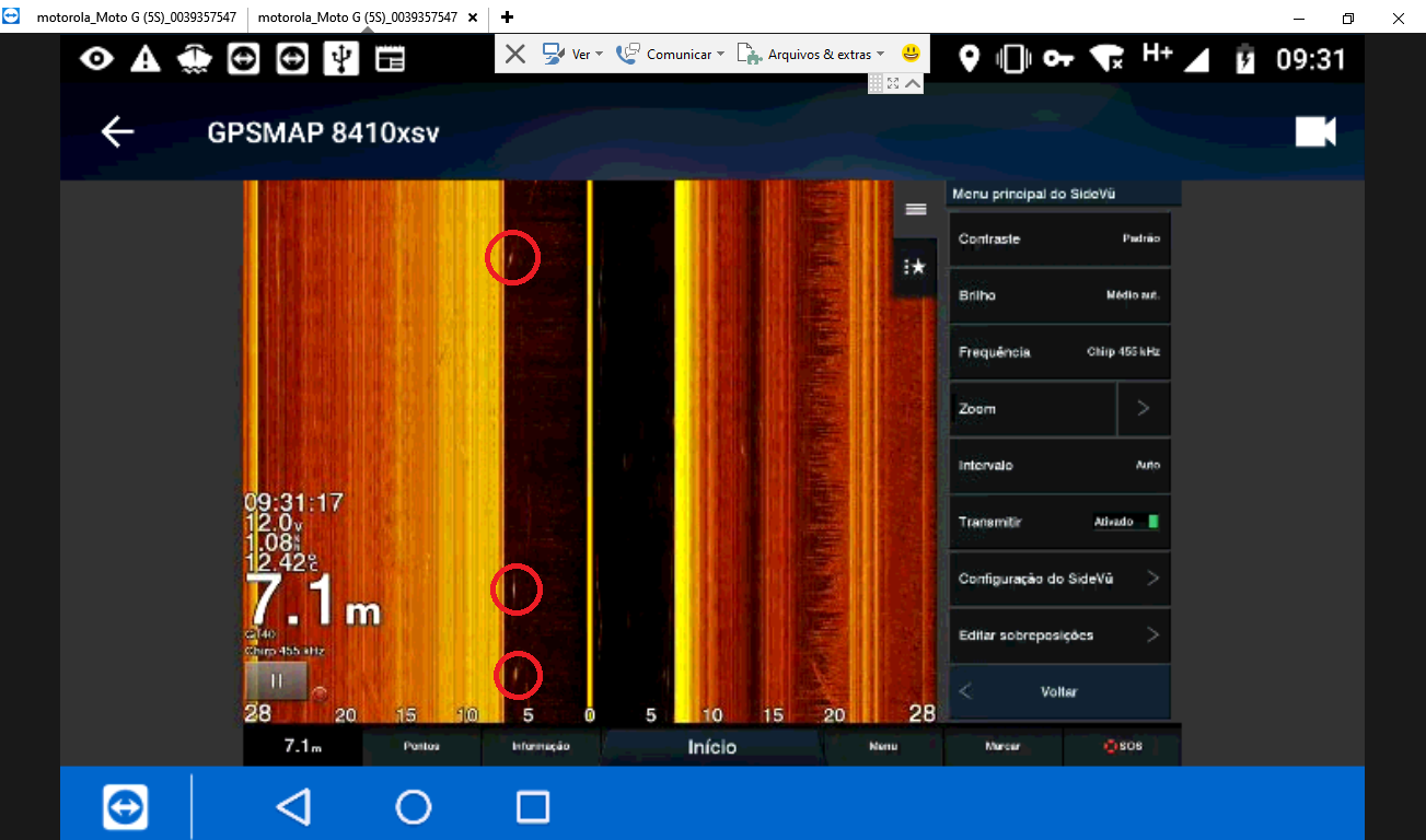
Image 07. Multi-frequency image of ichthyofauna movement (red circles) in the suction tube during the maintenance shutdown at generating units using PADS-enabled remote access.
Source: Author (2022)
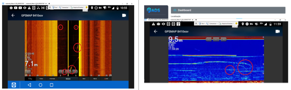
Image 08. Underwater multi-frequency image inside the spillway well (left) and in the driftwood retention system (right) using remote access through the PADS platform. The red circles indicate the presence and movement of ichthyofauna.
Source: Author (2022)
3.3 Discussion
The PADS platform allows for remote access to data, which brings significant advantages to the work of researchers, especially to those who carry out studies in the whereabouts or at the HPPs themselves. The technology offers a series of benefits but can present some difficulties related to the local internet network. The idea is to debate its benefits and disadvantages and the possibility of automation of other processes. One of the main benefits of this type of proposal is to offer an excellent cost-benefit ratio. Free and open-source technologies make access to development tools easier and often at no additional cost. Furthermore, it reduces the development time both for hardware and software.
Also, researchers can access data and configurations of the sonar device, which means that the researcher does not have to be present to collect data and change the capture configurations of the device, which in turn makes operational processes more agile. In the traditional process, each new capture that uses a SONAR depends on the movement of equipment and researchers involved in the process.
One hindrance of the proposed methodology application is the reliance on internet connection. In short, to be able to use the PADS, the researcher depends on a good connection on both ends: both in their homes, university, workplace, as well as for PADS, which also rely on network access.
4 CONCLUSIONS
The commissions performed with the PADS platform and its remote access services show a genuine possibility to automate processes, monitor activities, and capture data remotely. The usage of PADS can lower field operating costs and probably offer continuous remote monitoring of areas where once it was not possible.
Furthermore, its construction cost is relatively low, which increases the possibilities for the adoption and use of the proposal. By using accessible technologies, we were able to do a rapid assembly. The use of widely used components in the automation industry makes procurement and replacement of parts a relatively simple task.
In short, the field experiments verified the feasibility of the developed technology.
5 ACKNOWLEDGEMENTS
The author would like to thank immensely the University of Brasília (UnB) – Campus Planaltina, the company Venturo Consultoria Ambiental, the R&D Program of Energia Sustentável do Brasil (ANEEL/PD-06631-0009/2019), the operating and maintenance team at HPP Jirau for the support offered to this project.
6 REFERENCES
ALVES, D. C. et al. Protocol for the assessment of mortality and injuries in fish larvae associated with their downstream passage through hydropower dams. Rev Fish Biol Fisheries, v. 29, n. 2, p. 501–512, 1 jun. 2019.
ANDRADE, A.; SOMA, A.; EIKI, C. Automação de baixo custo baseada no Raspberry Pi. [s.l: s.n.].
BROWN, R. S. et al. Quantifying Mortal Injury of Juvenile Chinook Salmon Exposed to Simulated Hydro-Turbine Passage. Transactions of the American Fisheries Society, v. 141, n. 1, p. 147–157, 1 jan. 2012.
BUSCOMBE, D. Shallow water benthic imaging and substrate characterization using recreational-grade sidescan-sonar. Environmental Modelling & Software, v. 89, p. 1–18, 1 mar. 2017.
CARRINGTON, G.; STEPHENSON, J. The politics of energy scenarios: Are International Energy Agency and other conservative projections hampering the renewable energy transition? Energy research & social science, v. 46, p. 103–113, 2018.
DA SILVA, T. M.; FIGUEIREDO, W. S.; ZARA, L. F. Manobra de elevação da velocidade do fluxo hidráulico para a repulsão da ictiofauna em unidades geradoras tipo bulbo–Usina Hidrelétrica Jirau. 2021.
DE ENERGIA ELÉTRICA, E. A. E. Empresa de Pesquisa Energética. Rio de Janeiro, 2016.
DE PEIXES, S. P. A. T. SIDNEY LAZARO MARTINS. PhD Thesis—[s.l.] Universidade de São Paulo, 2005.
ESCHB.P.M, VAN; SPIERTSI.L.Y. Validation of a model to predict fish passage mortality in pumping stations. Canadian Journal of Fisheries and Aquatic Sciences, 2 set. 2014.
HARRISON, P. M. et al. Turbine entrainment and passage of potadromous fish through hydropower dams: Developing conceptual frameworks and metrics for moving beyond turbine passage mortality. Fish and Fisheries, v. 20, n. 3, p. 403–418, 2019.
MORETTO, E. M. et al. Histórico, tendências e perspectivas no planejamento espacial de usinas hidrelétricas brasileiras: a antiga e atual fronteira Amazônica. Ambiente & Sociedade, v. 15, p. 141–164, 2012.
PRADO, I. G. AVALIAÇÃO DO COMPORTAMENTO DE PEIXES À MONTANTE DA BARRAGEM DA UHE TRÊS MARIAS COMO SUBSÍDIO PARA A CONSERVAÇÃO DA ICTIOFAUNA. p. 93, 2012.
SIMMONDS, J.; MACLENNAN, D. N. Fisheries Acoustics: Theory and Practice. [s.l.] John Wiley & Sons, 2008.
THÉRY, H.; MELLO-THÉRY, N. A. DE. O sistema elétrico brasileiro. Confins. Revue franco-brésilienne de géographie/Revista franco-brasilera de geografia, n. 26, 2016.
WESTPHAL, G. G. C. et al. Use of side-scan sonar for estimations of Crassostrea brasiliana (Lamarck, 1819) stocks in subtidal banks on the south coast of Brazil. Brazilian Journal of Oceanography, v. 64, n. 1, p. 49–56, mar. 2016.
WINEMILLER, K. O. et al. Balancing hydropower and biodiversity in the Amazon, Congo, and Mekong. Science, v. 351, n. 6269, p. 128–129, 8 jan. 2016.
1,2 Universidade de Brasília (UnB), Faculdade de Planaltina (FUP) – DF, 73.345-010, Brasil
3Universidade Estadual Paulista “Júlio de Mesquita Filho” (UNESP) – SP, 01419-901, Brasil
*e-mail: alexandresantoscompunb@gmail.com